
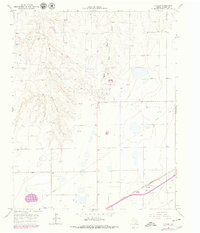
1966 Map of Cuyler
USGS Topo · Published 1967About this map
Industrial activity and the ranching landscape of the Texas Panhandle define this mid-century survey. The railway community of Cuyler serves as a focal point along the Atchison Topeka and Santa Fe line, where a prominent Grain Elevator stands as a testament to the region's agricultural output. The landscape is deeply influenced by the energy sector, as seen by the numerous installations labeled Gas Well, Oil Wells, and the network of underground pipelines that crisscross the terrain.
Find a feature on this map
13 named features on this map. Tap any name to fly to it.
Don’t see what you’re looking for? This feature index may not catch every label — zoom into the map to look around manually.
Map Details
Editions of this 1966 Cuyler Map
2 editions found
Other maps of this area

1953 · Borger SE
USGS Topo · 1:24,000

1953 · McBride
USGS Topo · 1:24,000

1954 · Amarillo
USGS Topo · 1:250,000

1958 · Amarillo
USGS Topo · 1:250,000

1963 · Skellytown
USGS Topo · 1:24,000

1965 · White Deer
USGS Topo · 1:24,000

1965 · Abell
USGS Topo · 1:24,000

1966 · Panhandle West
USGS Topo · 1:24,000

1966 · Panhandle East
USGS Topo · 1:24,000

1966 · White Deer SW
USGS Topo · 1:24,000