
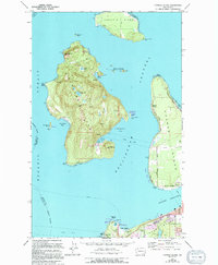
1973 Map of Cypress Island
USGS Topo · Published 1977About this map
Cypress Island and its surrounding archipelago define this maritime landscape in the early 1970s, showcasing a network of island settlements and navigation aids. The island itself, largely undeveloped, features interior water bodies like Phebe Lake and Duck Lake, along with a Prospect and a Mine near Secret Harbor, hinting at the area's geological interests. To the north, Sinclair Island is home to the small settlement of Urban, while Guemes Island to the east contains the Indian Village and Eden Cem.
Find a feature on this map
49 named features on this map. Tap any name to fly to it.
Don’t see what you’re looking for? This feature index may not catch every label — zoom into the map to look around manually.
Map Details
Editions of this 1973 Cypress Island Map
2 editions found
Other maps of this area

1943 · Richardson
USGS Topo · 1:62,500

1943 · Orcas Island
USGS Topo · 1:62,500

1943 · Deception Pass
USGS Topo · 1:62,500

1943 · Anacortes
USGS Topo · 1:62,500

1951 · Deception Pass
USGS Topo · 1:62,500

1951 · Anacortes
USGS Topo · 1:62,500

1957 · Richardson
USGS Topo · 1:62,500

1957 · Orcas Island
USGS Topo · 1:62,500

1957 · Victoria
USGS Topo · 1:250,000
1973 · Lopez Pass
USGS Topo · 1:24,000