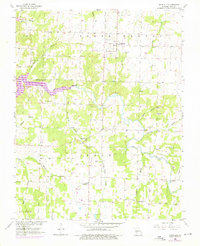
1955 Map of Dadeville
USGS Topo · Published 1976About this map
Stockton Lake and the meandering Sac River dominate this Missouri landscape, which was captured during a 1955 field check and updated with 1975 revisions. The map reveals a rural community where local history is anchored by family and community institutions, particularly in the settlement of Dadeville. The presence of Halston Mill along the river highlights early local industry, while several country churches, including New Hope Ch and Pleasant Hill Ch, serve as social anchors for the surrounding farmsteads. The terrain is crisscrossed by numerous small waterways like Corry Branch and Cave Spring Branch, which likely influenced the placement of early homesteads and roads. For genealogists, the map is especially useful for its precise location of small family and community burial grounds such as Logan Cem, Masonic Cem, and Wheeler Cem, providing a detailed look at the Polk and Dade County border region.
Find a feature on this map
31 named features on this map. Tap any name to fly to it.
Don’t see what you’re looking for? This feature index may not catch every label — zoom into the map to look around manually.
Map Details
Editions of this 1955 Dadeville Map
2 editions found
Other maps of this area

1886 · Stockton
USGS Topo · 1:125,000

1886 · Greenfield
USGS Topo · 1:125,000

1888 · Greenfield
USGS Topo · 1:125,000

1954 · Springfield
USGS Topo · 1:250,000

1955 · Dadeville
USGS Topo · 1:24,000

1956 · Ash Grove
USGS Topo · 1:24,000
1956 · Walnut Grove
USGS Topo · 1:24,000

1956 · Greenfield
USGS Topo · 1:24,000
1956 · Bona
USGS Topo · 1:24,000
1956 · South Greenfield
USGS Topo · 1:24,000