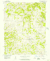
1956 Map of Walnut Grove
USGS Topo · Published 1957About this map
Walnut Grove serves as the central hub of this 1950s survey, where the St Louis San Francisco railroad cuts a diagonal path through the southwestern Missouri landscape. The map reveals a rural economy transitioning between traditional agriculture and industrial extraction, most notably at Phenix where Quarries are marked near the southern border. The terrain is defined by the winding course of Turkey Creek and the Sac River, which drain the rolling hills of the Jackson and Walnut Grove townships. For genealogists and local historians, the sheet is exceptionally detailed with family and community landmarks, including Turkey Creek Ch, Harold Ch, and several small burial grounds such as Green Lawn Cem, Williamson Cem, and Lennon Cem. The presence of Graydon Springs and Leith Spring highlights the importance of natural water sources in the early development of these Polk and Greene county borderlands.
Find a feature on this map
31 named features on this map. Tap any name to fly to it.
Don’t see what you’re looking for? This feature index may not catch every label — zoom into the map to look around manually.
Map Details
Editions of this 1956 Walnut Grove Map
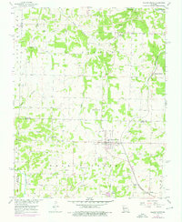
2 editions found
Other maps of this area

1884 · Springfield
USGS Topo · 1:125,000

1884 · Bolivar
USGS Topo · 1:125,000

1886 · Stockton
USGS Topo · 1:125,000

1886 · Greenfield
USGS Topo · 1:125,000

1886 · Springfield
USGS Topo · 1:125,000

1888 · Greenfield
USGS Topo · 1:125,000

1892 · Bolivar
USGS Topo · 1:125,000

1948 · Willard
USGS Topo · 1:24,000

1954 · Springfield
USGS Topo · 1:250,000

1955 · Dadeville
USGS Topo · 1:24,000