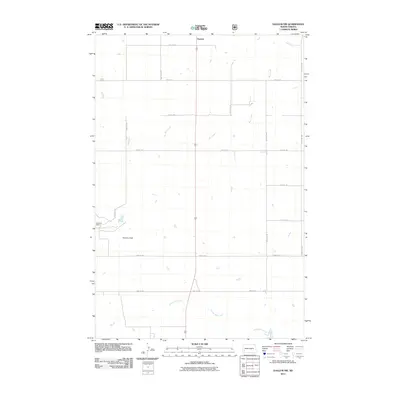
2011 Map of Daglum NW
USGS Topo · Published 2011About this map
Gaylord sits at the northern edge of this high plains landscape, anchoring a rural grid of section roads in Stark County. The terrain is defined by the dendritic patterns of Bull Creek and Adobe Wall Creek, which carve subtle drainages through the prairie. This 2011 survey illustrates the endurance of large-scale ranching and agriculture, noted by the presence of Swenson Ranch and the nearby Swenson Field. The map reveals a strictly organized infrastructure, where long thoroughfares like 132nd Ave SW and 52nd St SW facilitate movement across the wide distances between homesteads. It reflects the modern geography of Western North Dakota, where the traditional ranching economy persists alongside established land survey divisions.
Find a feature on this map
16 named features on this map. Tap any name to fly to it.
Don’t see what you’re looking for? This feature index may not catch every label — zoom into the map to look around manually.
Map Details
Editions of this 2011 Daglum NW Map
This is the sole edition of this map. No revisions or reprints were ever made.
Other maps of this area

1953 · Dickinson
USGS Topo · 1:250,000

1957 · Dickinson
USGS Topo · 1:250,000

1961 · Daglum
USGS Topo · 1:62,500

1961 · Rocky Ridge
USGS Topo · 1:62,500

1962 · Belfield SW
USGS Topo · 1:24,000

1962 · Fryburg
USGS Topo · 1:24,000

1962 · Belfield SE
USGS Topo · 1:24,000

1980 · Belfield
USGS Topo · 1:100,000
1982 · Daglum NW
USGS Topo · 1:24,000
1982 · Daglum SW
USGS Topo · 1:24,000