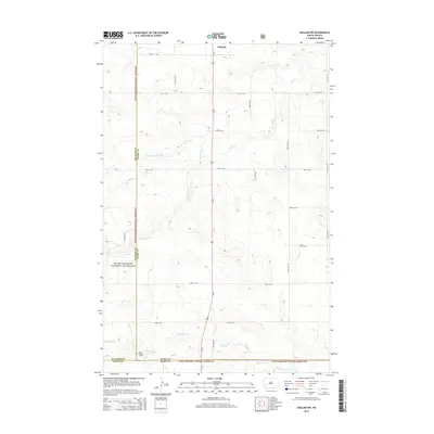
2014 Map of Daglum NW
USGS Topo · Published 2014About this map
The Little Missouri National Grassland dominates this high-plains landscape where Stark, Billings, and Slope Counties meet. In the early 21st century, this area remains characterized by its expansive public lands and the industrial footprint of the Rocky Ridge Oilfield in the southwest. The terrain is deeply etched by a network of drainage systems, including the Adobe Wall Cr and several branches of Bull Cr, which provide the primary topographic relief in an otherwise gridded agricultural and range environment. Human settlement is sparse, centered on the location of Gaylord along the north-south artery of Us-85. The map reveals a rigid section-line road system, with routes like 46th St SW and 131st Ave SW providing access across the vast open spaces of the Dakotas.
Find a feature on this map
25 named features on this map. Tap any name to fly to it.
Don’t see what you’re looking for? This feature index may not catch every label — zoom into the map to look around manually.
Map Details
Editions of this 2014 Daglum NW Map
This is the sole edition of this map. No revisions or reprints were ever made.
Other maps of this area

1953 · Dickinson
USGS Topo · 1:250,000

1957 · Dickinson
USGS Topo · 1:250,000

1961 · Daglum
USGS Topo · 1:62,500

1961 · Rocky Ridge
USGS Topo · 1:62,500

1962 · Belfield SW
USGS Topo · 1:24,000

1962 · Fryburg
USGS Topo · 1:24,000

1962 · Belfield SE
USGS Topo · 1:24,000

1980 · Belfield
USGS Topo · 1:100,000
1982 · Daglum NW
USGS Topo · 1:24,000
1982 · Daglum SW
USGS Topo · 1:24,000