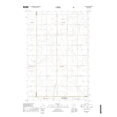
2018 Map of Daglum NW
USGS Topo · Published 2018About this map
Little Missouri National Grassland dominates the southern landscape of this 2018 survey, where the drainages of Adobe Wall Creek and Bull Creek carve into the high plains of western North Dakota. This section of the badlands is defined by its drainage systems, including the North Fork Bull Creek and South Fork Bull Creek, which form an intricate network of coulees and draws across the Stark, Billings, and Slope county lines. The modern infrastructure of US Hwy 85 bisects the terrain, providing a north-south corridor through the open range. Unlike more developed areas, the landscape here remains largely defined by the Public Land Survey System grid, with section lines and gravel roads like 130th Ave SW and 47th St SW serving as the primary landmarks for ranching operations and land management in this portion of the Little Missouri basin.
Find a feature on this map
30 named features on this map. Tap any name to fly to it.
Don’t see what you’re looking for? This feature index may not catch every label — zoom into the map to look around manually.
Map Details
Editions of this 2018 Daglum NW Map
This is the sole edition of this map. No revisions or reprints were ever made.
Other maps of this area

1953 · Dickinson
USGS Topo · 1:250,000

1957 · Dickinson
USGS Topo · 1:250,000

1961 · Daglum
USGS Topo · 1:62,500

1961 · Rocky Ridge
USGS Topo · 1:62,500

1962 · Belfield SW
USGS Topo · 1:24,000

1962 · Fryburg
USGS Topo · 1:24,000

1962 · Belfield SE
USGS Topo · 1:24,000

1980 · Belfield
USGS Topo · 1:100,000
1982 · Daglum NW
USGS Topo · 1:24,000
1982 · Daglum SW
USGS Topo · 1:24,000