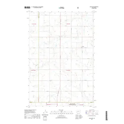
2020 Map of Daglum NW
USGS Topo · Published 2020About this map
Bull Creek and its major tributaries, including North Fork Bull Creek and South Fork Bull Creek, carve a distinct drainage pattern across this high plains landscape. This portion of the North Dakota badlands shows the intersection of Stark, Billings, and Slope Counties, where the land is primarily organized by a rigid section-line road grid such as 130th Ave SW. A significant portion of the southern terrain is preserved as part of the Little Missouri National Grassland. Cultural landmarks are sparse, making Our Lady of Lourdes Cemetery a prominent point of interest for local history. The map also records Adobe Wall Creek in the south, further illustrating the intricate network of seasonal waterways that define the local topography.
Find a feature on this map
32 named features on this map. Tap any name to fly to it.
Don’t see what you’re looking for? This feature index may not catch every label — zoom into the map to look around manually.
Map Details
Editions of this 2020 Daglum NW Map
This is the sole edition of this map. No revisions or reprints were ever made.
Other maps of this area

1953 · Dickinson
USGS Topo · 1:250,000

1957 · Dickinson
USGS Topo · 1:250,000

1961 · Daglum
USGS Topo · 1:62,500

1961 · Rocky Ridge
USGS Topo · 1:62,500

1962 · Belfield SW
USGS Topo · 1:24,000

1962 · Fryburg
USGS Topo · 1:24,000

1962 · Belfield SE
USGS Topo · 1:24,000

1980 · Belfield
USGS Topo · 1:100,000
1982 · Daglum NW
USGS Topo · 1:24,000
1982 · Daglum SW
USGS Topo · 1:24,000