
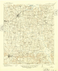
1914 Map of Daingerfield
USGS Topo · Published 1914About this map
Daingerfield anchors this pre-World War I survey of the Piney Woods region, serving as a vital rail junction where the Missouri Kansas and Texas RR meets local industrial lines. The landscape is defined by a dense network of rural infrastructure, from the Logging RR tracks in the east to the numerous community hubs like Hollingsworth Church and Friendship Church. The northern border follows the Sulphur R and Jennings Lake, while the interior is heavily settled with neighborhood schools such as Gethsemane School and Boon Hall. Settlement patterns follow the ridge lines between drainage basins like Caney Creek and Cypress Creek, illustrating how geography dictated the placement of small agricultural communities like Marietta and Seymour before modern highway development reshaped the county.
Find a feature on this map
63 named features on this map. Tap any name to fly to it.
Don’t see what you’re looking for? This feature index may not catch every label — zoom into the map to look around manually.
Map Details
Editions of this 1914 Daingerfield Map
2 editions found
Other maps of this area

1909 · New Boston
USGS Topo · 1:62,500

1910 · Linden
USGS Topo · 1:62,500

1930 · Bassett
USGS Topo · 1:62,500

1953 · Texarkana
USGS Topo · 1:250,000

1955 · Corley
USGS Topo · 1:24,000

1955 · New Boston
USGS Topo · 1:62,500

1956 · Texarkana
USGS Topo · 1:250,000

1956 · Tyler
USGS Topo · 1:250,000

1960 · La Fayette
USGS Topo · 1:24,000

1961 · Cunningham Creek
USGS Topo · 1:24,000