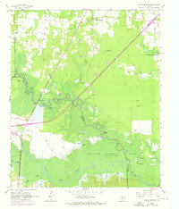
1965 Map of Dalby Springs
USGS Topo · Published 1976About this map
Dalby Springs sits at the northern edge of a landscape defined by the confluence of the Sulphur River and White Oak Creek. This 1960s survey documents a region of transition, where the expanding waters of Wright Patman Lake begin to inundate the low-lying bottomlands. The map reveals a mosaic of wetland features like Molly Clark Slough and Greenhaw Lake set against the higher ground of Willow Bluff.
Find a feature on this map
39 named features on this map. Tap any name to fly to it.
Don’t see what you’re looking for? This feature index may not catch every label — zoom into the map to look around manually.
Map Details
Editions of this 1965 Dalby Springs Map
2 editions found
Other maps of this area

1914 · Daingerfield
USGS Topo · 1:62,500

1930 · Bassett
USGS Topo · 1:62,500

1953 · Texarkana
USGS Topo · 1:250,000

1956 · Texarkana
USGS Topo · 1:250,000

1965 · Lydia
USGS Topo · 1:24,000
1965 · Hodgson
USGS Topo · 1:24,000

1965 · Marietta
USGS Topo · 1:24,000
1965 · Malta
USGS Topo · 1:24,000

1965 · Dalby Springs
USGS Topo · 1:24,000
1965 · Bassett
USGS Topo · 1:24,000