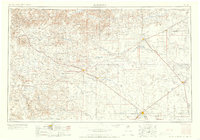
1958 Map of Dalhart
USGS Topo · Published 1958About this map
Sierra Grande and Capulin Mountain dominate the western high plains in this mid-century look at the multi-state junction where the Texas Panhandle meets Oklahoma and New Mexico. The region's heavy reliance on rail and ranching is evident in the network of the Atchison Topeka and Santa Fe and the Beaver Meade & Englewood railroads, which connect agricultural hubs like Boise City and Stratford. In the southern reaches, the city of Dalhart serves as a critical crossroads near Lake Rita Blanca, supported by military installations including Dalhart Air Force No. 1. The drainage patterns of the North Canadian River and Cimarron River cut through the high tablelands, defining the routes between old cattle-country settlements like Grenville, Texline, and Clayton. This survey captures the landscape before the expansion of modern highway networks, highlighting the original post-war layout of the Tri-State area.
Find a feature on this map
46 named features on this map. Tap any name to fly to it.
Don’t see what you’re looking for? This feature index may not catch every label — zoom into the map to look around manually.
Map Details
Editions of this 1958 Dalhart Map
2 editions found

Other maps of this area

1891 · Springfield
USGS Topo · 1:125,000

1891 · Mesa De Maya
USGS Topo · 1:125,000

1892 · Vilas
USGS Topo · 1:125,000

1892 · Elmoro
USGS Topo · 1:125,000

1892 · Mt Carrizo
USGS Topo · 1:125,000

1893 · Elmoro
USGS Topo · 1:125,000

1893 · Springfield
USGS Topo · 1:125,000

1893 · Mesa de Maya
USGS Topo · 1:125,000

1897 · Elmoro
USGS Topo · 1:125,000

1954 · Santa Fe
USGS Topo · 1:250,000