
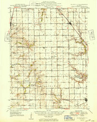
1949 Map of Dalton City
USGS Topo · Published 1949About this map
Dalton City and Macon anchor a landscape defined by the intersection of the Illinois Central and Chicago & Eastern Illinois railroads in the late 1940s. This survey of central Illinois reveals a high density of rural institutions, with dozens of family-named schools and churches serving the agricultural townships of South Macon, Milam, and Pickaway. The map provides a detailed view of the region before modern agricultural consolidation, preserving the locations of smaller community centers like Yantisville and Prairie Home.
Find a feature on this map
68 named features on this map. Tap any name to fly to it.
Don’t see what you’re looking for? This feature index may not catch every label — zoom into the map to look around manually.
Map Details
Editions of this 1949 Dalton City Map
2 editions found
Other maps of this area

1929 · Decatur
USGS Topo · 1:62,500

1933 · Decatur
USGS Topo · 1:62,500

1935 · Sullivan
USGS Topo · 1:48,000

1940 · Sullivan
USGS Topo · 1:62,500

1942 · Shelbyville
USGS Topo · 1:62,500

1946 · Shelbyville
USGS Topo · 1:62,500

1947 · Pana
USGS Topo · 1:62,500

1947 · Stewardson
USGS Topo · 1:62,500

1949 · Stewardson
USGS Topo · 1:62,500

1949 · Pana
USGS Topo · 1:62,500