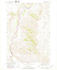
1954 Map of Dalzell SE
USGS Topo · Published 1979About this map
The Cheyenne River winds through this West River landscape, defining the boundary where Meade and Pennington counties meet. Historically mapped in the mid-1950s and updated in the late 1970s, the terrain is characterized by a complex network of drainage systems including Dalzell Canyon, Big Canyon, and Little Canyon. These deep cuts through the prairie reveal a sparsely populated ranching environment where water and high ground dictated human activity.
Find a feature on this map
14 named features on this map. Tap any name to fly to it.
Don’t see what you’re looking for? This feature index may not catch every label — zoom into the map to look around manually.
Map Details
Editions of this 1954 Dalzell SE Map
2 editions found
Other maps of this area

1953 · Rapid City
USGS Topo · 1:250,000

1954 · Dalzell SE
USGS Topo · 1:24,000

1954 · Dalzell NW
USGS Topo · 1:24,000

1954 · Wasta NE
USGS Topo · 1:24,000

1954 · Dalzell
USGS Topo · 1:24,000

1954 · Wasta NW
USGS Topo · 1:24,000

1954 · Dalzell NE
USGS Topo · 1:24,000

1955 · Pedro NW
USGS Topo · 1:24,000

1955 · Creighton
USGS Topo · 1:24,000

1957 · Rapid City
USGS Topo · 1:250,000