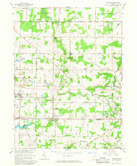
1966 Map of Damascus
USGS Topo · Published 1968About this map
The boundary between Mahoning and Columbiana counties anchors this mid-century survey, centered on the community of Damascus. This agricultural and residential landscape is defined by the historically significant South Boundary of the Connecticut Western Reserve, a line that separated early colonial land grants and still shapes the township grids today. Transport through the region was heavily influenced by the Penn Central and Pennsylvania railroad lines, which served smaller hubs like Beloit, Snodes, and Garfield. Notable local landmarks include the West Branch High School, Westville Lake, and recreational sites like Camp Merrydale and the Salem Country Club. The map reveals a transition from traditional farming toward suburban growth, evidenced by the development of Salem Heights and the network of local roads such as Diagonal Road and Goshen Road.
Find a feature on this map
68 named features on this map. Tap any name to fly to it.
Don’t see what you’re looking for? This feature index may not catch every label — zoom into the map to look around manually.
Map Details
Editions of this 1966 Damascus Map
2 editions found
Other maps of this area

1906 · Ravenna
USGS Topo · 1:62,500

1908 · Warren
USGS Topo · 1:62,500

1908 · Ravenna
USGS Topo · 1:62,500

1909 · Alliance
USGS Topo · 1:62,500

1909 · Lisbon
USGS Topo · 1:62,500

1950 · Cleveland
USGS Topo · 1:250,000

1951 · Canton
USGS Topo · 1:250,000

1952 · Lake Milton
USGS Topo · 1:24,000

1952 · Canfield
USGS Topo · 1:24,000

1952 · Alliance
USGS Topo · 1:24,000