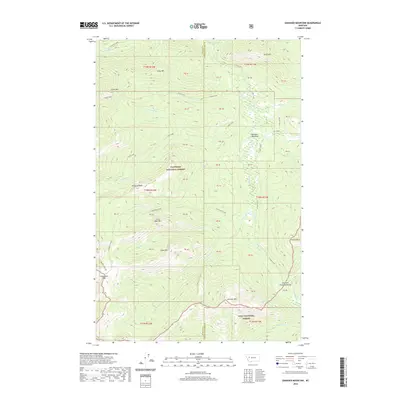
2020 Map of Danaher Mountain
USGS Topo · Published 2020About this map
Danaher Meadows serves as a central landmark within this high-elevation wilderness, where the borders of the Flathead National Forest and Lolo National Forest converge. The terrain is defined by a series of prominent peaks and ridgelines, including Alloy Mtn and Grace Mtn in the north, and the namesake Danaher Mtn to the south. The drainage patterns are complex, with the E Side S Fork and its tributaries like Danaher Cr and Spring Cr carving through the landscape. This area represents a critical hydrological divide, marked clearly by the Blackfoot Divide and the Dry Fork Flathead Divide. Notable transit points for early backcountry travelers include Limestone Pass, providing a window into the historical navigation of the Lewis and Clark County and Powell County high country before modern infrastructure.
Find a feature on this map
39 named features on this map. Tap any name to fly to it.
Don’t see what you’re looking for? This feature index may not catch every label — zoom into the map to look around manually.
Map Details
Editions of this 2020 Danaher Mountain Map
This is the sole edition of this map. No revisions or reprints were ever made.
Other maps of this area

1902 · Ovando
USGS Topo · 1:125,000

1903 · Coopers Lake
USGS Topo · 1:125,000

1905 · Ovando
USGS Topo · 1:125,000

1955 · Choteau
USGS Topo · 1:250,000

1957 · Choteau
USGS Topo · 1:250,000

1958 · Choteau
USGS Topo · 1:250,000

1962 · Choteau
USGS Topo · 1:250,000

1968 · Spread Mountain
USGS Topo · 1:24,000

1968 · Dunham Point
USGS Topo · 1:24,000
1968 · Lake Mountain
USGS Topo · 1:24,000