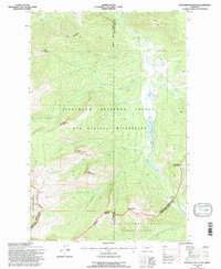
1994 Map of Danaher Mountain
USGS Topo · Published 1997About this map
The Powell and Lewis and Clark County line bisects this high-elevation landscape, where the Bob Marshall Wilderness and Scapegoat Wilderness converge. Centered on the towering presence of Danaher Mountain, the terrain is defined by a dense network of drainages that feed the Dry Fork North Fork Blackfoot River and the upper reaches of Danaher Creek. The map documents a strictly protected wilderness environment, showing no modern roads but tracing vital mountain passes like Limestone Pass and high ridges including the Dry Fork Flathead Divide. Topographic details reveal a series of notable summits, from Alloy Mountain and Grace Mountain in the north to Apex Mountain and Concord Mountain further south. Isolated structures like the Danaher Cabin provide rare evidence of human habitation in this remote region of the Flathead National Forest.
Find a feature on this map
32 named features on this map. Tap any name to fly to it.
Don’t see what you’re looking for? This feature index may not catch every label — zoom into the map to look around manually.
Map Details
Editions of this 1994 Danaher Mountain Map
This is the sole edition of this map. No revisions or reprints were ever made.
Other maps of this area

1902 · Ovando
USGS Topo · 1:125,000

1903 · Coopers Lake
USGS Topo · 1:125,000

1905 · Ovando
USGS Topo · 1:125,000

1955 · Choteau
USGS Topo · 1:250,000

1957 · Choteau
USGS Topo · 1:250,000

1958 · Choteau
USGS Topo · 1:250,000

1962 · Choteau
USGS Topo · 1:250,000

1968 · Spread Mountain
USGS Topo · 1:24,000

1968 · Dunham Point
USGS Topo · 1:24,000
1968 · Lake Mountain
USGS Topo · 1:24,000