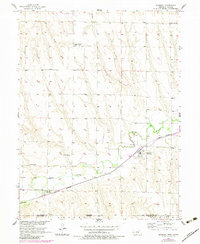
1957 Map of Danbury
USGS Topo · Published 1983About this map
Beaver Creek flows through the southern portion of this landscape, carving a valley that dictated the placement of early 20th-century transportation and settlement. The Burlington Northern railroad corridor serves as the primary artery for the region, connecting the village of Danbury with the smaller community of Marion to the west. This 1957 survey, updated with photo revisions in 1981, captures the rural infrastructure of the Nebraska-Kansas border before significant farm consolidation.
Find a feature on this map
14 named features on this map. Tap any name to fly to it.
Don’t see what you’re looking for? This feature index may not catch every label — zoom into the map to look around manually.
Map Details
Editions of this 1957 Danbury Map
2 editions found
Other maps of this area

1951 · Oberlin
USGS Topo · 1:62,500

1951 · Kanona
USGS Topo · 1:62,500

1954 · McCook
USGS Topo · 1:250,000

1954 · Goodland
USGS Topo · 1:250,000

1956 · Goodland
USGS Topo · 1:250,000

1957 · McCook
USGS Topo · 1:250,000

1957 · Goodland
USGS Topo · 1:250,000

1957 · Danbury
USGS Topo · 1:24,000

1957 · Lebanon
USGS Topo · 1:24,000

1957 · McCook SE
USGS Topo · 1:24,000