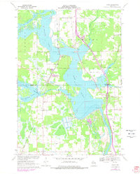
1970 Map of Dancy
USGS Topo · Published 1978About this map
The Wisconsin River corridor dominates this 1970s landscape, featuring the broad expanse of Lake Du Bay and the intricate wetlands of the Little Eau Pleine Flowage. The settlement of Dancy sits at the junction of the Chicago Milwaukee St Paul and Pacific railroad and the river, serving as a focal point alongside nearby Knowlton. The map reveals a community structured around its spiritual and educational centers, including St Johns Ch and the Knowlton Sch.
Find a feature on this map
38 named features on this map. Tap any name to fly to it.
Don’t see what you’re looking for? This feature index may not catch every label — zoom into the map to look around manually.
Map Details
Editions of this 1970 Dancy Map
3 editions found
Other maps of this area

1899 · Wausau
USGS Topo · 1:125,000

1902 · Wausau
USGS Topo · 1:125,000

1902 · Marathon
USGS Topo · 1:125,000

1953 · Wausau
USGS Topo · 1:48,000

1953 · Marathon
USGS Topo · 1:48,000

1955 · Green Bay
USGS Topo · 1:250,000

1956 · Milladore
USGS Topo · 1:48,000

1956 · Stevens Point
USGS Topo · 1:48,000

1963 · Marathon
USGS Topo · 1:62,500

1963 · Wausau
USGS Topo · 1:62,500