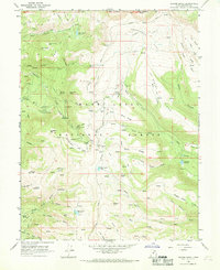
1966 Map of Danish Knoll
USGS Topo · Published 1969About this map
The high plateau of the Manti-La Sal National Forest is defined here by a network of scientific stations and water management infrastructure during the mid-1960s. Research activity is anchored by the Great Basin Experiment Station and the Alpine Experiment Station, while the ridgeline is traced by the iconic Skyline Drive. The landscape is etched with irrigation and water transport features, including the Horseshoe Tunnel and Larsen Tunnel, which move water through the high divides to support the valley below. Notable landmarks such as Danish Knoll, Swedish Knoll, and Elks Knoll suggest the cultural imprint of early settlers in the region. Water remains central to the map's character, with several high-elevation impoundments like New Canyon Reservoir, Petes Hole Reservoir, and Loggers Fork Reservoir scattered among the peaks of Middle Mountain and South Mountain.
Find a feature on this map
67 named features on this map. Tap any name to fly to it.
Don’t see what you’re looking for? This feature index may not catch every label — zoom into the map to look around manually.
Map Details
Editions of this 1966 Danish Knoll Map
2 editions found
Other maps of this area

1885 · Manti
USGS Topo · 1:250,000

1895 · Manti
USGS Topo · 1:250,000

1922 · Wasatch
USGS Topo · 1:31,680

1956 · Price
USGS Topo · 1:250,000

1960 · Price
USGS Topo · 1:250,000

1962 · Price
USGS Topo · 1:250,000

1965 · Black Mountain
USGS Topo · 1:24,000
1966 · Ferron Reservoir
USGS Topo · 1:24,000

1966 · Spring City
USGS Topo · 1:24,000

1966 · Chester
USGS Topo · 1:24,000