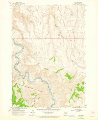
1962 Map of Dant
USGS Topo · Published 1964About this map
The Deschutes River carves a deep, winding path through this portion of Wasco County, serving as the primary corridor for transportation and settlement. Along its banks, the Oregon Trunk (Spokane Portland and Seattle) railroad follows the water's edge, connecting small stops such as Dant and Dixon. The landscape is defined by dramatic elevation changes, moving from the riverbed up into the high reaches of the Mutton Mountains. A significant historical demarcation, the Warm Springs Indian Reservation Boundary (Mc Quinn Line 1884), cuts across the southern portion of the map near Eagle Creek, marking a clear division in land use and jurisdiction. Away from the river, the terrain is characterized by a network of drainage canyons like Chicken Canyon and Williams Canyon, while the presence of the Two Springs Ranch and isolated mines suggests a reliance on ranching and small-scale resource extraction in this arid environment.
Find a feature on this map
23 named features on this map. Tap any name to fly to it.
Don’t see what you’re looking for? This feature index may not catch every label — zoom into the map to look around manually.
Map Details
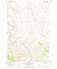
Editions of this 1962 Dant Map
2 editions found
Other maps of this area

1928 · Madras
USGS Topo · 1:125,000

1930 · Dufur
USGS Topo · 1:125,000

1931 · Madras
USGS Topo · 1:125,000

1934 · Dufur
USGS Topo · 1:125,000

1953 · The Dalles
USGS Topo · 1:250,000

1955 · Bend
USGS Topo · 1:250,000

1956 · The Dalles
USGS Topo · 1:250,000

1957 · Bend
USGS Topo · 1:250,000

1957 · The Dalles
USGS Topo · 1:250,000

1958 · Bend
USGS Topo · 1:250,000