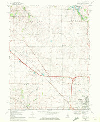
1970 Map of Danvers SE
USGS Topo · Published 1972About this map
The northwest expansion of Normal and the surrounding McLean County agricultural landscape are captured during a period of infrastructure growth and academic extension. The State University Farm and Fairview Park occupy the urban fringe near the newly established Interstate routes. To the north, the creation of Evergreen Lake along Sixmile Creek shows the changing hydrology of the region, while the small settlement of Yuton remains tied to the Norfolk and Western rail lines. Family history is deeply rooted in the rural townships, evidenced by numerous small burial grounds like Denman Cem, Troyer Cem, and Kopp Cem that dot the creek valleys. The landscape is a mix of traditional landmarks, such as the East White Oak Bible Ch and Oakdale Sch, alongside mid-century additions like Weight Stations and Gas Storage facilities.
Find a feature on this map
31 named features on this map. Tap any name to fly to it.
Don’t see what you’re looking for? This feature index may not catch every label — zoom into the map to look around manually.
Map Details
Editions of this 1970 Danvers SE Map
2 editions found
Other maps of this area

1926 · Normal
USGS Topo · 1:62,500

1927 · Danvers
USGS Topo · 1:62,500

1930 · Danvers
USGS Topo · 1:62,500

1930 · Normal
USGS Topo · 1:62,500

1949 · Mc Lean
USGS Topo · 1:62,500

1951 · McLean
USGS Topo · 1:62,500

1951 · Le Roy
USGS Topo · 1:62,500

1958 · Peoria
USGS Topo · 1:250,000

1961 · Peoria
USGS Topo · 1:250,000

1963 · Peoria
USGS Topo · 1:250,000