
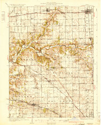
1930 Map of Danvers
USGS Topo · Published 1930About this map
The Mackinaw River cuts a deep, winding course across this central Illinois landscape, creating the distinct terrain of Mackinaw Dells in the western townships. This late 1920s survey reveals a dense network of one-room schoolhouses, such as Olive Branch Sch and Panther Creek Sch, serving established farming communities in Olio and White Oak. The infrastructure of the era is defined by the coexistence of heavy rail and interurban transit, including the Illinois Terminal (Electric) and the Toledo Peoria and Western. The transition from rural homesteads to village centers is evident in settlements like Danvers and Carlock, while landmarks like the Town Hall in Dry Grove and Centennial Chapel mark the social centers of the day. The map captures the agricultural interior of the state before the consolidation of rural school districts changed the local geography.
Find a feature on this map
86 named features on this map. Tap any name to fly to it.
Don’t see what you’re looking for? This feature index may not catch every label — zoom into the map to look around manually.
Map Details
Editions of this 1930 Danvers Map
2 editions found
Other maps of this area

1893 · Metamora
USGS Topo · 1:62,500

1926 · Normal
USGS Topo · 1:62,500

1927 · Danvers
USGS Topo · 1:62,500

1928 · Mackinaw
USGS Topo · 1:62,500

1930 · Normal
USGS Topo · 1:62,500

1932 · Mackinaw
USGS Topo · 1:62,500

1937 · Metamora
USGS Topo · 1:62,500

1948 · Metamora
USGS Topo · 1:62,500

1949 · Mc Lean
USGS Topo · 1:62,500

1951 · McLean
USGS Topo · 1:62,500