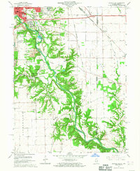
1966 Map of Danville SE
USGS Topo · Published 1967About this map
The Vermilion River carves a deep, forested corridor through the heart of the central Illinois prairie on this mid-1960s survey. To the north, the expanding margins of Danville are marked by institutional and civic landmarks including the VA Hospital and St Patrick Sch. The landscape is a complex mix of agriculture, active industry, and scientific research, evidenced by the Strip Mine operations south of Grape Creek and the notable University of Illinois Radio Telescope situated near the Observatory.
Find a feature on this map
64 named features on this map. Tap any name to fly to it.
Don’t see what you’re looking for? This feature index may not catch every label — zoom into the map to look around manually.
Map Details
Editions of this 1966 Danville SE Map
2 editions found
Other maps of this area

1899 · Danville
USGS Topo · 1:62,500

1900 · Danville
USGS Topo · 1:62,500

1947 · Ridge Farm
USGS Topo · 1:62,500

1948 · Danville NW
USGS Topo · 1:24,000

1949 · Danville SW
USGS Topo · 1:24,000

1950 · Danville SW
USGS Topo · 1:24,000

1950 · Danville NW
USGS Topo · 1:24,000

1950 · Danville SE
USGS Topo · 1:24,000

1950 · Danville NE
USGS Topo · 1:24,000

1951 · Danville NE
USGS Topo · 1:24,000