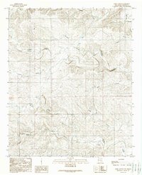
1988 Map of Dark Canyon
USGS Topo · Published 1989About this map
Dagger Lake and a network of remote watering points define this arid corner of Chaves County during the late 1980s. The landscape is marked by its reliance on subterranean water sources, evidenced by numerous named wells such as Solo Well, Barbara Well, and the South Turknett Well. These features, along with several landmarks like the Challenge Windmill and East Header Windmill, reveal the infrastructure necessary for sustaining life and livestock in the high desert.
Find a feature on this map
24 named features on this map. Tap any name to fly to it.
Don’t see what you’re looking for? This feature index may not catch every label — zoom into the map to look around manually.
Map Details
Editions of this 1988 Dark Canyon Map
This is the sole edition of this map. No revisions or reprints were ever made.
Other maps of this area

1954 · Carlsbad
USGS Topo · 1:250,000

1955 · Roswell
USGS Topo · 1:250,000

1958 · Carlsbad
USGS Topo · 1:250,000

1958 · Roswell
USGS Topo · 1:250,000

1960 · Teel Ranch
USGS Topo · 1:62,500

1961 · Flying H
USGS Topo · 1:62,500

1961 · Indian Bluff
USGS Topo · 1:62,500

1962 · Roswell
USGS Topo · 1:250,000

1962 · Dunken
USGS Topo · 1:62,500

1978 · Artesia
USGS Topo · 1:100,000