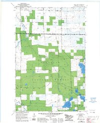
1955 Map of Dark Lake
USGS Topo · Published 1985About this map
Sturgeon River State Forest and the Superior National Forest converge in this northern Minnesota landscape, where a complex network of waterways defines the terrain. The Sturgeon River meanders through the northwest, joined by Gilmore Creek and the Branch Sturgeon River. A striking pattern of state and federal land management is visible, with the National Forest Boundary cutting through timberlands and marshes.
Find a feature on this map
29 named features on this map. Tap any name to fly to it.
Don’t see what you’re looking for? This feature index may not catch every label — zoom into the map to look around manually.
Map Details
Editions of this 1955 Dark Lake Map
3 editions found
Other maps of this area

1951 · Kinney
USGS Topo · 1:24,000

1952 · Idington
USGS Topo · 1:24,000

1954 · Hibbing
USGS Topo · 1:250,000

1955 · Dark Lake
USGS Topo · 1:24,000

1955 · Dewey Lake SE
USGS Topo · 1:24,000

1955 · Dewey Lake NW
USGS Topo · 1:24,000

1955 · Dewey Lake
USGS Topo · 1:24,000

1957 · Hibbing
USGS Topo · 1:250,000

1958 · Hibbing
USGS Topo · 1:250,000

1964 · Hibbing
USGS Topo · 1:250,000