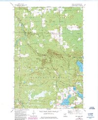
1955 Map of Dark Lake
USGS Topo · Published 1985About this map
Alango Hall stands as a focal point in the northern portion of this St. Louis County landscape, marking a localized pocket of community activity amidst a vast network of protected timberlands and waterways. The area is defined by the intersection of the Sturgeon River State Forest and the Superior National Forest, where the Sturgeon River and the Dark River carve through the terrain. Evidence of local industry and infrastructure is present in the form of a Gravel Pit and a designated Heliport near the water. The map traces an intricate drainage system including Paavola Creek, Leander Creek, and West Knuckey Creek, which feed into prominent water bodies like Great Dark Lake and Knuckey Lake. This mid-century survey, updated in the 1980s, highlights the enduring character of the Iron Range periphery where forest management and glacial lakes dominate the geography.
Find a feature on this map
25 named features on this map. Tap any name to fly to it.
Don’t see what you’re looking for? This feature index may not catch every label — zoom into the map to look around manually.
Map Details
Editions of this 1955 Dark Lake Map
3 editions found
Other maps of this area

1951 · Kinney
USGS Topo · 1:24,000

1952 · Idington
USGS Topo · 1:24,000

1954 · Hibbing
USGS Topo · 1:250,000

1955 · Dark Lake
USGS Topo · 1:24,000

1955 · Dewey Lake SE
USGS Topo · 1:24,000

1955 · Dewey Lake NW
USGS Topo · 1:24,000

1955 · Dewey Lake
USGS Topo · 1:24,000

1957 · Hibbing
USGS Topo · 1:250,000

1958 · Hibbing
USGS Topo · 1:250,000

1964 · Hibbing
USGS Topo · 1:250,000