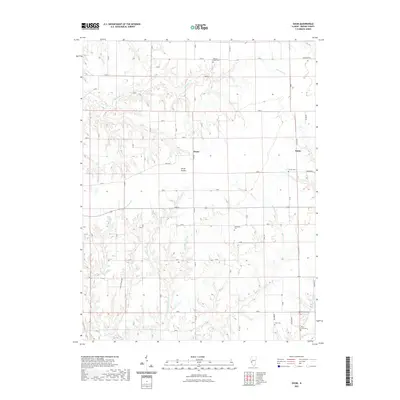
2021 Map of Daum
USGS Topo · Published 2021About this map
Daum and String Prairie anchor this agricultural landscape in Greene County, where the topography is defined by the incision of Whitaker Cr and Bear Cr into the Illinois prairie. The map reveals a dense network of family and community history preserved in numerous burial grounds, including the centrally located Hardin Cem and the north-lying Hickory Grove Cem. The presence of Little Bear Rough suggests more dissected, wooded terrain tucked between the broader farm plots. This modern survey provides a detailed view of rural infrastructure, from established county roads like Co RD 6 to specialized tracks such as Koster Farms Dr, tracing the persistence of small settlements like Kahm and the geographic reach of Taylor Cr in the southeastern corner.
Find a feature on this map
27 named features on this map. Tap any name to fly to it.
Don’t see what you’re looking for? This feature index may not catch every label — zoom into the map to look around manually.
Map Details
Editions of this 2021 Daum Map
This is the sole edition of this map. No revisions or reprints were ever made.
Other maps of this area

1924 · Roodhouse
USGS Topo · 1:62,500

1925 · Brighton
USGS Topo · 1:62,500

1926 · Roodhouse
USGS Topo · 1:62,500

1928 · Brighton
USGS Topo · 1:62,500

1930 · Jerseyville
USGS Topo · 1:62,500

1932 · Greenfield
USGS Topo · 1:62,500

1933 · Jerseyville
USGS Topo · 1:62,500

1948 · Quincy
USGS Topo · 1:250,000

1956 · Quincy
USGS Topo · 1:250,000
1983 · Boyer Creek
USGS Topo · 1:24,000