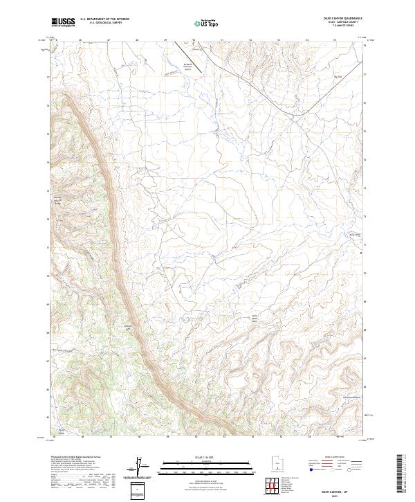
2023 Map of Dave Canyon
USGS Topo · Published 2023About this map
The Straight Cliffs dominate the western portion of this Garfield County landscape, marking a sharp geological transition above the drainage of Dave Canyon. This modern survey illustrates a high desert environment where access is defined by remote thoroughfares like Smokey Mt Rd and Sawmill Rd. Near the northern border, the Escalante Municipal Airport serves as a critical navigation point amidst the broad expanse of Big Flat. The terrain is characterized by intricate erosional features, including Serenity Natural Bridge and Cedar Wash Arch, alongside seasonal watercourses such as Alvey Wash and Bull Run Canyon. These named landmarks provide essential orientation for researchers and travelers navigating the complex canyon systems and plateaus of southern Utah.
Find a feature on this map
16 named features on this map. Tap any name to fly to it.
Don’t see what you’re looking for? This feature index may not catch every label — zoom into the map to look around manually.
Map Details
Editions of this 2023 Dave Canyon Map
This is the sole edition of this map. No revisions or reprints were ever made.
Other maps of this area

1886 · Escalante
USGS Topo · 1:250,000

1956 · Escalante
USGS Topo · 1:250,000

1960 · Escalante
USGS Topo · 1:250,000

1964 · Tenmile Flat
USGS Topo · 1:24,000

1964 · Dave Canyon
USGS Topo · 1:24,000
1964 · Calf Creek
USGS Topo · 1:24,000

1964 · Canaan Creek
USGS Topo · 1:24,000

1964 · Seep Flat
USGS Topo · 1:24,000

1964 · Death Ridge
USGS Topo · 1:24,000

1964 · Carcass Canyon
USGS Topo · 1:24,000