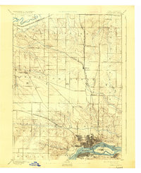
1894 Map of Davenport
USGS Topo · Published 1927About this map
The Mississippi River defines the southern edge of this late 19th-century Iowa landscape, where the dense street grid of Davenport meets the river's bend at Rock Island. To the north, the terrain transitions into the organized townships of Sheridan and Lincoln, marked by a lattice of agricultural sections and early rail lines. The Chicago Milwaukee and St. Paul Railroad serves as a primary north-south spine, connecting the major rail junction at Eldridge with smaller agricultural hubs like Long Grove and Donahue. Further north, the Wapsipinicon River meanders across the border of Allens Grove and Winfield townships. Of particular note for local historians is the Green Tree Tavern along the road to Mount Joy, a clear landmark of pre-automotive travel patterns in the rural spaces between the river and the northern railroad crossings.
Find a feature on this map
36 named features on this map. Tap any name to fly to it.
Don’t see what you’re looking for? This feature index may not catch every label — zoom into the map to look around manually.
Map Details
Editions of this 1894 Davenport Map
4 editions found

Other maps of this area

1890 · Durant
USGS Topo · 1:62,500

1891 · DeWitt
USGS Topo · 1:62,500

1891 · Davenport
USGS Topo · 1:62,500

1892 · Wheatland
USGS Topo · 1:62,500

1892 · Goose Lake
USGS Topo · 1:62,500

1892 · Leclaire
USGS Topo · 1:62,500

1893 · Leclaire
USGS Topo · 1:62,500

1894 · Wheatland
USGS Topo · 1:62,500

1894 · Durant
USGS Topo · 1:62,500

1894 · Goose Lake
USGS Topo · 1:62,500