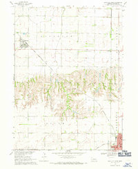
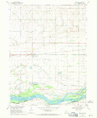
1968 Map of David City West
USGS Topo · Published 1971About this map
David City and the village of Bellwood anchor this 1960s landscape, illustrating the agricultural and transit patterns of the Missouri River Basin. The terrain is defined by the contrast between flat upland plains and the complex drainage systems of Bone Creek and Deer Creek. Transport infrastructure is prominent, with the Chicago Burlington and Quincy railroad cutting diagonally across the northern townships, while the Union Pacific line serves the southeastern corner at the edge of the county seat.
Find a feature on this map
18 named features on this map. Tap any name to fly to it.
Don’t see what you’re looking for? This feature index may not catch every label — zoom into the map to look around manually.
Map Details
Editions of this 1968 David City West Map
This is the sole edition of this map. No revisions or reprints were ever made.
Other maps of this area

1899 · David City
USGS Topo · 1:125,000

1955 · Fremont
USGS Topo · 1:250,000

1957 · Fremont
USGS Topo · 1:250,000

1958 · Fremont
USGS Topo · 1:250,000

1958 · Columbus SE
USGS Topo · 1:24,000

1958 · Columbus
USGS Topo · 1:24,000
1965 · Brainard
USGS Topo · 1:24,000
1965 · Garrison
USGS Topo · 1:24,000
1965 · Rising City
USGS Topo · 1:24,000
1968 · Richland
USGS Topo · 1:24,000