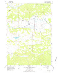
1965 Map of Davis Hill
USGS Topo · Published 1978About this map
Three Rivers Ranch and several other valley outposts sit along the winding riverbanks of this Teton County landscape during the mid-1960s. The terrain is defined by the significant hydrological intersection of Pacific Creek and the Buffalo Fork, which meander through a series of meadows and draws. The southern portion of the map is dominated by the Elk Ranch Reservoir, featuring a clearly marked spillway, and the prominent rise of Uhl Hill.
Find a feature on this map
40 named features on this map. Tap any name to fly to it.
Don’t see what you’re looking for? This feature index may not catch every label — zoom into the map to look around manually.
Map Details
Editions of this 1965 Davis Hill Map
3 editions found
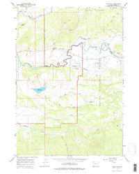
Other maps of this area

1899 · Grand Teton
USGS Topo · 1:125,000

1901 · Grand Teton
USGS Topo · 1:125,000

1902 · Mt Leidy
USGS Topo · 1:125,000

1955 · Driggs
USGS Topo · 1:250,000

1958 · Driggs
USGS Topo · 1:250,000

1962 · Driggs
USGS Topo · 1:250,000

1965 · Davis Hill
USGS Topo · 1:24,000

1965 · Green Mountain
USGS Topo · 1:24,000

1965 · Rosies Ridge
USGS Topo · 1:24,000

1965 · Mount Leidy
USGS Topo · 1:24,000