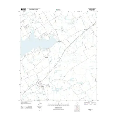
2013 Map of Dawson
USGS Topo · Published 2013About this map
The town of Dawson serves as the focal point for this section of Navarro County, exhibiting a grid of streets such as N Fullerton and N Gilmer Ave that contrast with the winding rural routes nearby. Water management is a defining characteristic of the landscape, seen in the large expanse of Navarro Mills Lake and a series of smaller reservoirs, including Soil Conservation Service Site 112 Reservoir and Soil Conservation Service Site 113 Reservoir, which regulate the flow of Richland Cr and its tributaries. For researchers, the map identifies small communities like Spring Hill, Silver City, and Alliance Hall, along with the Knapp Pecan Orchard Airpark. Several local landmarks are preserved in the documentation, including Spring Hill Cem and Younger Cem, reflecting the area's agricultural and genealogical roots in the early 21st century.
Find a feature on this map
116 named features on this map. Tap any name to fly to it.
Don’t see what you’re looking for? This feature index may not catch every label — zoom into the map to look around manually.
Map Details
Editions of this 2013 Dawson Map
This is the sole edition of this map. No revisions or reprints were ever made.
Other maps of this area

1954 · Dallas
USGS Topo · 1:250,000

1954 · Waco
USGS Topo · 1:250,000

1955 · Waco
USGS Topo · 1:250,000

1956 · Hubbard
USGS Topo · 1:24,000

1956 · Dawson
USGS Topo · 1:24,000

1957 · Irene
USGS Topo · 1:24,000

1958 · Dallas
USGS Topo · 1:250,000

1965 · Coolidge
USGS Topo · 1:24,000
1965 · Blooming Grove
USGS Topo · 1:24,000
1965 · Corbet
USGS Topo · 1:24,000