
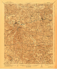
1911 Map of Dawson Springs
USGS Topo · Published 1911About this map
The Tradewater River winds through this 1911 survey of western Kentucky, serving as a natural boundary between Hopkins and Christian Counties. At this time, Dawson Springs had emerged as a central hub, bolstered by its location at the junction of the Illinois Central RR and local road networks. The landscape is dense with small rural settlements and industrial nodes, including the Fox Run Mine and communities like Saint Charles and Crabtree Ilsley PO.
Find a feature on this map
86 named features on this map. Tap any name to fly to it.
Don’t see what you’re looking for? This feature index may not catch every label — zoom into the map to look around manually.
Map Details
Editions of this 1911 Dawson Springs Map
2 editions found
Other maps of this area

1907 · Earlington
USGS Topo · 1:48,000

1908 · Princeton
USGS Topo · 1:62,500

1909 · Dawson Springs
USGS Topo · 1:48,000

1909 · Earlington
USGS Topo · 1:62,500

1909 · Madisonville
USGS Topo · 1:62,500

1909 · Providence
USGS Topo · 1:62,500

1910 · Princeton
USGS Topo · 1:62,500

1912 · Nortonville
USGS Topo · 1:62,500

1952 · Pleasant Green Hill
USGS Topo · 1:24,000

1952 · Kelly
USGS Topo · 1:24,000