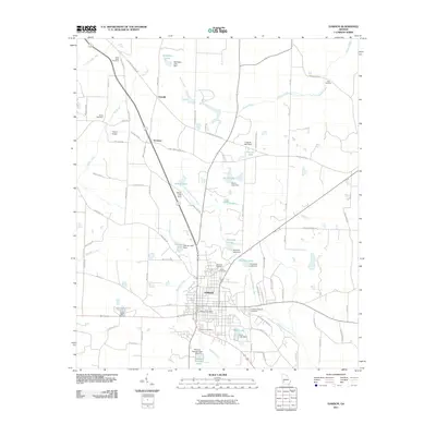
2011 Map of Dawson
USGS Topo · Published 2011About this map
Dawson serves as the focal point of this Terrell County landscape, where the town’s grid is bordered by numerous agricultural and water-management features. The surrounding countryside is defined by an extensive network of named creeks and managed reservoirs, including Chickasawhatchee Creek and Brantley Creek, which feed into local basins such as Belmar Lake and Chamblis Lake. For those tracing local heritage, the map identifies several well-spaced burial grounds like Saint Pauls Cemetery and Zion Cemetery, alongside smaller settlements like Yeomans and Oakville. The presence of the Cocke Fish Hatchery and Hayes Airport further indicates a mix of specialized land use and transportation infrastructure. This era of the landscape shows a mature rural infrastructure where industrial and municipal features, such as the Dawson Sewage Pond, exist alongside long-established family-named rural roads and farmland.
Find a feature on this map
82 named features on this map. Tap any name to fly to it.
Don’t see what you’re looking for? This feature index may not catch every label — zoom into the map to look around manually.
Map Details
Editions of this 2011 Dawson Map
This is the sole edition of this map. No revisions or reprints were ever made.
Other maps of this area

1953 · Dothan
USGS Topo · 1:250,000

1954 · Dothan
USGS Topo · 1:250,000

1955 · Dothan
USGS Topo · 1:250,000

1956 · Sasser
USGS Topo · 1:62,500

1972 · Parrott
USGS Topo · 1:24,000

1972 · Shellman
USGS Topo · 1:24,000

1973 · Chickasawhatchee
USGS Topo · 1:24,000

1973 · Sasser
USGS Topo · 1:24,000

1973 · Dawson
USGS Topo · 1:24,000
1973 · Bottsford
USGS Topo · 1:24,000