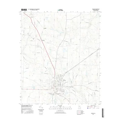
2017 Map of Dawson
USGS Topo · Published 2017About this map
The Terrell County seat of Dawson serves as the focal point for this Southwest Georgia study, situated at the intersection of several regional routes including Co RD 157 and Co RD 71. The landscape is defined by its agricultural character and a dense network of local roads such as Hoods Store Rd and Jones Mill Rd that connect the main town to smaller outlying settlements like Yeomans and Oakville. Water features are prominent throughout the region, with the winding Chickasawhatchee Cr and Mossy Cr cutting through the terrain alongside numerous named bodies of water like Chamblis Lake and Belmar Lake.
Find a feature on this map
108 named features on this map. Tap any name to fly to it.
Don’t see what you’re looking for? This feature index may not catch every label — zoom into the map to look around manually.
Map Details
Editions of this 2017 Dawson Map
This is the sole edition of this map. No revisions or reprints were ever made.
Other maps of this area

1953 · Dothan
USGS Topo · 1:250,000

1954 · Dothan
USGS Topo · 1:250,000

1955 · Dothan
USGS Topo · 1:250,000

1956 · Sasser
USGS Topo · 1:62,500

1972 · Parrott
USGS Topo · 1:24,000

1972 · Shellman
USGS Topo · 1:24,000

1973 · Chickasawhatchee
USGS Topo · 1:24,000

1973 · Sasser
USGS Topo · 1:24,000

1973 · Dawson
USGS Topo · 1:24,000
1973 · Bottsford
USGS Topo · 1:24,000