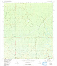
1954 Map of Day NW
USGS Topo · Published 1993About this map
San Pedro Bay dominates this section of Taylor County, Florida, revealing a vast wetland environment as it appeared during the mid-20th century. Based on 1950s planetable surveys with updates through the early 1990s, the map highlights the intricate drainage of the area, notably the Fenholloway River which flows through the southern portion of the quadrangle. The presence of an Old Railroad Grade in the southeast corner provides a clear link to the region's industrial past, likely associated with timber extraction or naval stores which were central to the local economy. A distinctive Spoil Bank cutting across the swampy terrain indicates human modification of the landscape, probably for water management or transportation access through the low-lying bay. These features together document a landscape where natural hydrology and industrial efforts to navigate it intersect.
Find a feature on this map
6 named features on this map. Tap any name to fly to it.
Don’t see what you’re looking for? This feature index may not catch every label — zoom into the map to look around manually.
Map Details
Editions of this 1954 Day NW Map
3 editions found
Other maps of this area

1954 · Fenholloway
USGS Topo · 1:24,000

1954 · Day SE
USGS Topo · 1:24,000

1954 · Day
USGS Topo · 1:24,000

1954 · Boyd
USGS Topo · 1:24,000

1954 · Day NW
USGS Topo · 1:24,000

1954 · Valdosta
USGS Topo · 1:250,000

1955 · Perry
USGS Topo · 1:24,000

1955 · Greenville SE
USGS Topo · 1:24,000

1958 · Valdosta
USGS Topo · 1:250,000

1958 · Madison SW
USGS Topo · 1:24,000