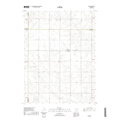
2017 Map of Daykin
USGS Topo · Published 2017About this map
Daykin serves as the central hub of this Jefferson County landscape, where the town plat follows a precise grid including Jefferson St, Francis St, and Marie St. The surrounding countryside is defined by the section-line road network and the meandering courses of Little Sandy Creek and South Fork Swan Creek. This region, where the borders of Fillmore, Saline, Thayer, and Jefferson counties converge, maintains a strictly agricultural character. Local history is anchored by sites such as Saint Johns Cemetery east of town and Eureka Cemetery to the northwest, near the Saline County line. Further south, the small settlement of Helvey sits along 564th Ave, illustrating the sparse but persistent distribution of rural communities in the plains.
Find a feature on this map
50 named features on this map. Tap any name to fly to it.
Don’t see what you’re looking for? This feature index may not catch every label — zoom into the map to look around manually.
Map Details
Editions of this 2017 Daykin Map
This is the sole edition of this map. No revisions or reprints were ever made.
Other maps of this area

1955 · Lincoln
USGS Topo · 1:250,000

1957 · Lincoln
USGS Topo · 1:250,000

1958 · Lincoln
USGS Topo · 1:250,000

1960 · Western SW
USGS Topo · 1:24,000

1960 · Fairbury
USGS Topo · 1:24,000

1960 · Tobias SW
USGS Topo · 1:24,000

1960 · Alexandria
USGS Topo · 1:24,000
1960 · Gladstone
USGS Topo · 1:24,000

1960 · Daykin
USGS Topo · 1:24,000

1961 · Tobias
USGS Topo · 1:24,000