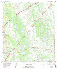
1962 Map of Daytona Beach SW
USGS Topo · Published 1988About this map
Daytona Park Estates represents the primary residential development in this portion of Volusia County, featuring a structured grid of streets such as Laurel Road and Orange Road. Surrounding this mid-century growth is a vast hydrological network characterized by wetlands and seasonal drainages. The landscape is dominated by Tiger Bay and Deep Creek, which dictate the local topography and historical land use. Scattered throughout these wetlands are various island formations including Dukes Islands, McKenzie Islands, and the curiously named Rattlesnake Island.
Find a feature on this map
26 named features on this map. Tap any name to fly to it.
Don’t see what you’re looking for? This feature index may not catch every label — zoom into the map to look around manually.
Map Details
Editions of this 1962 Daytona Beach SW Map
5 editions found
Other maps of this area

1952 · Samsula
USGS Topo · 1:24,000

1952 · Daytona Beach
USGS Topo · 1:24,000

1954 · Daytona Beach
USGS Topo · 1:250,000

1955 · Orlando
USGS Topo · 1:250,000

1957 · Orlando
USGS Topo · 1:250,000

1958 · Orlando
USGS Topo · 1:250,000

1958 · Daytona Beach
USGS Topo · 1:250,000

1962 · Orlando
USGS Topo · 1:250,000

1962 · Daytona Beach NW
USGS Topo · 1:24,000

1962 · Daytona Beach SW
USGS Topo · 1:24,000