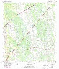
1962 Map of Daytona Beach SW
USGS Topo · Published 1988About this map
Daytona Park Estates sits at the intersection of a developing residential grid and the expansive wetlands of central Volusia County. This 1962 survey, updated with 1980s aerial data, reveals a landscape defined by water and drainage, where named features like Tiger Bay and Boggy Strand dominate the terrain. A series of residential streets including Laurel Road and Orange Road push eastward from the vicinity of Lake Winnemissett, abruptly meeting the natural boundary of the Deep Creek basin.
Find a feature on this map
25 named features on this map. Tap any name to fly to it.
Don’t see what you’re looking for? This feature index may not catch every label — zoom into the map to look around manually.
Map Details
Editions of this 1962 Daytona Beach SW Map
5 editions found
Other maps of this area

1952 · Samsula
USGS Topo · 1:24,000

1952 · Daytona Beach
USGS Topo · 1:24,000

1954 · Daytona Beach
USGS Topo · 1:250,000

1955 · Orlando
USGS Topo · 1:250,000

1957 · Orlando
USGS Topo · 1:250,000

1958 · Orlando
USGS Topo · 1:250,000

1958 · Daytona Beach
USGS Topo · 1:250,000

1962 · Orlando
USGS Topo · 1:250,000

1962 · Daytona Beach NW
USGS Topo · 1:24,000

1962 · Daytona Beach SW
USGS Topo · 1:24,000