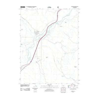
2011 Map of De Beque
USGS Topo · Published 2011About this map
De Beque serves as the central hub of this Western Slope landscape, where the confluence of Roan Creek and the Colorado River dictated the early settlement patterns and transport routes. The town’s grid is clearly defined by streets such as Glenwood Ave and Beaman Ave, reflecting its established residential and commercial footprint. The surrounding terrain is heavily influenced by water management for high-desert agriculture, visible in the extensive networks of the Bluestone Valley Ditch, Reservoir Ditch, and Larkin Ditch. To the east and south, the geography rises toward Horsethief Mountain and the high plateaus, while industrial activity is noted at the Nichols Pit. This topographic survey also identifies significant upland water storage at Piute Reservoir and Sunnyside Reservoir, which are vital for sustaining the valley's economy.
Find a feature on this map
40 named features on this map. Tap any name to fly to it.
Don’t see what you’re looking for? This feature index may not catch every label — zoom into the map to look around manually.
Map Details
Editions of this 2011 De Beque Map
This is the sole edition of this map. No revisions or reprints were ever made.
Other maps of this area

1929 · Grand Valley
USGS Topo · 1:62,500

1929 · Roan Creek
USGS Topo · 1:62,500

1955 · Cameo
USGS Topo · 1:24,000

1955 · Mesa
USGS Topo · 1:24,000

1955 · Molina
USGS Topo · 1:24,000

1956 · Grand Junction
USGS Topo · 1:250,000

1959 · Grand Junction
USGS Topo · 1:250,000

1960 · Grand Junction
USGS Topo · 1:250,000

1962 · Grand Junction
USGS Topo · 1:250,000
1962 · Grand Valley
USGS Topo · 1:24,000