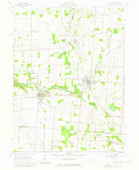
1961 Map of De Graff
USGS Topo · Published 1976About this map
De Graff (BM 1007) and Quincy serve as the primary hubs in this agricultural portion of Logan and Champaign counties. The landscape is defined by the winding course of the Great Miami River and its various tributaries like Stony Creek and Bokengehalas Creek. The presence of several distinct cemeteries, such as Knight Cem, Means Cem, and Olive Chapel Cem, provides significant points of interest for genealogical research in these rural townships.
Find a feature on this map
46 named features on this map. Tap any name to fly to it.
Don’t see what you’re looking for? This feature index may not catch every label — zoom into the map to look around manually.
Map Details
Editions of this 1961 De Graff Map
3 editions found
Other maps of this area

1913 · Bellefontaine
USGS Topo · 1:48,000

1913 · Sidney
USGS Topo · 1:62,500

1914 · Troy
USGS Topo · 1:62,500

1914 · St. Paris
USGS Topo · 1:62,500

1915 · Bellefontaine
USGS Topo · 1:62,500

1916 · St. Paris
USGS Topo · 1:62,500

1944 · Sidney
USGS Topo · 1:62,500

1944 · St. Paris
USGS Topo · 1:62,500

1944 · Troy
USGS Topo · 1:62,500

1944 · Bellefontaine
USGS Topo · 1:62,500