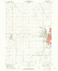
1971 Map of De Kalb
USGS Topo · Published 1973About this map
Northern Illinois University dominates the western edge of De Kalb, reflecting a period of significant institutional expansion in the early 1970s. The map illustrates a landscape transitioning from the grid-iron agricultural fields of South Grove and Milan townships to a growing suburban and academic center. The South Branch Kishwaukee River winds through the city's parks, including Lions Park and Lincoln Park, providing a natural corridor amid the residential blocks and the campus core. To the west, the village of Malta remains a distinct rail-oriented settlement along the Chicago and North Western line. This survey is particularly useful for genealogy, capturing numerous local schools such as Newman Sch and Lucinda Sch, along with well-established burial grounds like Hudson Cem and Malta Cem.
Find a feature on this map
53 named features on this map. Tap any name to fly to it.
Don’t see what you’re looking for? This feature index may not catch every label — zoom into the map to look around manually.
Map Details
Editions of this 1971 De Kalb Map
2 editions found
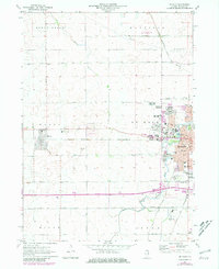
Other maps of this area

1918 · Kirkland
USGS Topo · 1:62,500

1934 · De Kalb
USGS Topo · 1:62,500

1937 · De Kalb
USGS Topo · 1:62,500

1937 · Sycamore
USGS Topo · 1:62,500

1938 · Genoa
USGS Topo · 1:62,500

1954 · Rockford
USGS Topo · 1:250,000

1955 · Rockford
USGS Topo · 1:250,000

1958 · Aurora
USGS Topo · 1:250,000

1958 · Rockford
USGS Topo · 1:250,000

1961 · Aurora
USGS Topo · 1:250,000