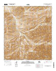
2015 Map of De Long Mountains B-2 NE
USGS Topo · Published 2015About this map
The Kukpowruk River snakes through the high-elevation terrain of this Arctic landscape, representing a remote portion of the Brooks Range foothills. In the southern reaches of the quadrangle, the Noatak National Preserve encompasses a significant portion of the wild terrain, protecting a landscape that has remained largely unchanged for centuries. The elevation reaches a distinct peak at Chevron Hill in the northeast, while the headwaters of the Wulik River begin their journey toward the Chukchi Sea from the southern slopes. This 2015 study by the U.S. Geological Survey illustrates a geography defined by its dramatic contours and glacial history rather than human infrastructure, serving as a primary reference for the hydrologic patterns and natural boundaries of the Noatak National Preserve.
Find a feature on this map
8 named features on this map. Tap any name to fly to it.
Don’t see what you’re looking for? This feature index may not catch every label — zoom into the map to look around manually.
Map Details
Editions of this 2015 De Long Mountains B-2 NE Map
This is the sole edition of this map. No revisions or reprints were ever made.
Other maps of this area

1951 · De Long Mountains
USGS Topo · 1:250,000

1955 · De Long Mountains
USGS Topo · 1:250,000
1955 · De Long Mountains C-2
USGS Topo · 1:63,360
1955 · De Long Mountains C-1
USGS Topo · 1:63,360

1955 · De Long Mountains B-2
USGS Topo · 1:63,360
1955 · De Long Mountains B-1
USGS Topo · 1:63,360

1965 · De Long Mountains
USGS Topo · 1:250,000
2014 · De Long Mountains C-2 SW
USGS Topo · 1:25,000
2015 · De Long Mountains B-2 SE
USGS Topo · 1:25,000
2015 · De Long Mountains B-2 SW
USGS Topo · 1:25,000