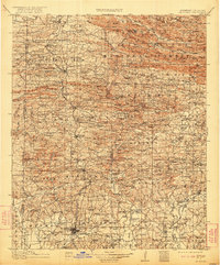
1913 Map of De Queen
USGS Topo · Published 1922About this map
The Kansas City Southern RR corridor forms the backbone of development through western Arkansas, connecting mountain timber towns like Hatfield, Vandervoort, and Gillham. Within the expansive Arkansas National Forest, the landscape is defined by the Cross Mountains and Saline Mountain, where early resource extraction is evidenced by the Shady Mine.
Find a feature on this map
173 named features on this map. Tap any name to fly to it.
Don’t see what you’re looking for? This feature index may not catch every label — zoom into the map to look around manually.
Map Details
Editions of this 1913 De Queen Map
4 editions found
Other maps of this area

1890 · Mount Ida
USGS Topo · 1:125,000

1890 · Poteau Mountain
USGS Topo · 1:125,000

1899 · Poteau Mountain
USGS Topo · 1:125,000

1900 · Winding Stair
USGS Topo · 1:125,000

1902 · Lukfata
USGS Topo · 1:125,000

1906 · Caddo Gap
USGS Topo · 1:125,000

1909 · Winding Stair
USGS Topo · 1:125,000

1913 · De Queen
USGS Topo · 1:125,000

1936 · Athens
USGS Topo · 1:48,000

1942 · Athens
USGS Topo · 1:62,500