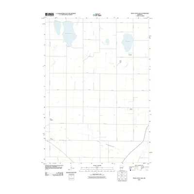
2010 Map of Dead Coon Lake
USGS Topo · Published 2010About this map
Dead Coon Lake and Wood Lake anchor this agricultural landscape in southwestern Minnesota, where a grid of rural routes defines the movement across Lincoln County. The map captures a moment of managed water resources, featuring the Coon Creek Dam and the meandering path of Coon Creek as it feeds into the lakes. To the south, the Redwood River and Judicial Ditch Number Thirtyone illustrate the region's historical reliance on drainage infrastructure to support its farming economy. This survey is particularly valuable for genealogical research, as it identifies several distinct burial grounds that served the surrounding farmstead communities, including Hope Cemetery, Saint Dionysius Cemetery, Mission Cemetery, and Wood Lake Cemetery. These landmarks provide a framework for understanding the early 21st-century rural layout before modern developments further altered the agrarian character of the Tyler vicinity.
Find a feature on this map
30 named features on this map. Tap any name to fly to it.
Don’t see what you’re looking for? This feature index may not catch every label — zoom into the map to look around manually.
Map Details
Editions of this 2010 Dead Coon Lake Map
This is the sole edition of this map. No revisions or reprints were ever made.
Other maps of this area

1953 · Watertown
USGS Topo · 1:250,000

1953 · New Ulm
USGS Topo · 1:250,000

1957 · New Ulm
USGS Topo · 1:250,000

1958 · New Ulm
USGS Topo · 1:250,000

1958 · Watertown
USGS Topo · 1:250,000

1963 · Dead Coon Lake
USGS Topo · 1:24,000

1963 · Gislason Lake
USGS Topo · 1:24,000

1963 · Russell
USGS Topo · 1:24,000

1963 · Tyler
USGS Topo · 1:24,000

1963 · Lynd
USGS Topo · 1:24,000