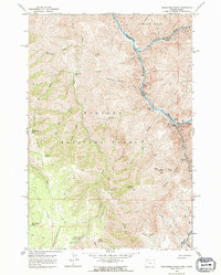
1963 Map of Deadhorse Ridge
USGS Topo · Published 1974About this map
Wallowa National Forest dominates this 1963 survey, revealing a landscape defined by the confluence of the Snake River and the Imnaha River. The area shows significant evidence of historical mining activity, particularly in the southeastern quadrant where several named claims such as the Mountain Chief Mine, Mabel L Mine, and Bonnie Doone No 1 Mine are clustered near Toomey Gulch. This concentration of mines suggests a period of intensive prospecting in the difficult terrain above the river canyons.
Find a feature on this map
50 named features on this map. Tap any name to fly to it.
Don’t see what you’re looking for? This feature index may not catch every label — zoom into the map to look around manually.
Map Details
Editions of this 1963 Deadhorse Ridge Map
3 editions found
Other maps of this area

1954 · Imnaha
USGS Topo · 1:62,500

1954 · Kernan Point
USGS Topo · 1:62,500

1955 · Grangeville
USGS Topo · 1:250,000

1959 · Grangeville
USGS Topo · 1:250,000

1963 · Cactus Mtn
USGS Topo · 1:24,000

1963 · Deadhorse Ridge
USGS Topo · 1:24,000

1963 · Jim Creek Butte
USGS Topo · 1:24,000

1963 · Rattlesnake Ridge
USGS Topo · 1:24,000

1963 · Wapshilla Creek
USGS Topo · 1:24,000

1963 · Poison Point
USGS Topo · 1:24,000