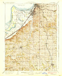
1927 Map of Dearborn
USGS Topo · Published 1927About this map
The Missouri River corridor south of Saint Joseph was a bustling landscape of rail and river industry at the time of this 1927 edition. Numerous rail lines converge on the city, including the Chicago Rock Island and Pacific RR and the Chicago Burlington and Quincy RR, carving paths through the loess hills of Buchanan Co and Platte Co. The map reveals an intricate network of rural life, anchored by numerous small educational institutions such as the Spring Garden School and Pickett School, alongside vanished junctions like Lake Station. In the river bottoms, old oxbows such as Contrary Lake and Horseshoe Lake indicate the river's shifting path before extensive modern channelization. The transition from the urban grid of South Saint Joseph to the scattered townships of Washington, Crawford, and Marshall illustrates a period when community identity was tied to local landmarks like Sparta Church and Brownley Chapel.
Find a feature on this map
83 named features on this map. Tap any name to fly to it.
Don’t see what you’re looking for? This feature index may not catch every label — zoom into the map to look around manually.
Map Details
Editions of this 1927 Dearborn Map
3 editions found

Other maps of this area

1885 · Atchison
USGS Topo · 1:125,000

1886 · Oskaloosa
USGS Topo · 1:125,000

1888 · Oskaloosa
USGS Topo · 1:125,000

1888 · Atchison
USGS Topo · 1:125,000

1890 · Kansas City
USGS Topo · 1:125,000

1893 · Atchison
USGS Topo · 1:125,000

1894 · Kansas City
USGS Topo · 1:125,000

1894 · Oskaloosa
USGS Topo · 1:125,000

1910 · Leavenworth
USGS Topo · 1:62,500

1914 · Smithville
USGS Topo · 1:62,500