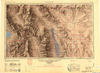
1948 Map of Death Valley
USGS Topo · Published 1951About this map
Death Valley National Monument and its surrounding desert basins are captured here following a 1947 compilation by the Army Map Service. The landscape is defined by its extreme elevations and sparse but vital water sources, with the Panamint Range rising sharply above the salt flats. This era shows the region as a mix of active outposts and the remains of early 20th-century mining booms. Scattered settlements such as Beatty, Rhyolite, and Carrara appear along the eastern edge, while the interior of the monument is anchored by Furnace Creek Ranch and Stovepipe Wells.
Find a feature on this map
118 named features on this map. Tap any name to fly to it.
Don’t see what you’re looking for? This feature index may not catch every label — zoom into the map to look around manually.
Map Details
Editions of this 1948 Death Valley Map
2 editions found

Other maps of this area

1905 · Olancha
USGS Topo · 1:125,000

1906 · Kernville
USGS Topo · 1:125,000

1907 · Olancha
USGS Topo · 1:125,000

1907 · Mt. Whitney
USGS Topo · 1:125,000

1907 · Las Vegas
USGS Topo · 1:250,000

1908 · Kawich
USGS Topo · 1:250,000

1908 · Lida
USGS Topo · 1:250,000

1908 · Furnace Creek
USGS Topo · 1:250,000

1908 · Las Vegas
USGS Topo · 1:250,000

1908 · Kernville
USGS Topo · 1:125,000