
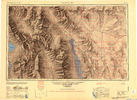
1948 Map of Death Valley
USGS Topo · Published 1948About this map
Death Valley National Monument anchors this 1948 military and geological survey, capturing the region's sparse settlements and intense topography just after World War II. The landscape is defined by the sharp verticality of the Panamint Range and Argus Range, dropping into the sink of Death Valley where Furnace Creek Ranch and Stovepipe Wells serve as isolated outposts. To the west, Owens Lake sits at the base of the Inyo National Forest, connected to the wider world by the Southern Pacific railroad line near Keeler.
Find a feature on this map
113 named features on this map. Tap any name to fly to it.
Don’t see what you’re looking for? This feature index may not catch every label — zoom into the map to look around manually.
Map Details
Editions of this 1948 Death Valley Map
2 editions found
Other maps of this area

1905 · Olancha
USGS Topo · 1:125,000

1906 · Kernville
USGS Topo · 1:125,000

1907 · Olancha
USGS Topo · 1:125,000

1907 · Mt. Whitney
USGS Topo · 1:125,000

1907 · Las Vegas
USGS Topo · 1:250,000

1908 · Kawich
USGS Topo · 1:250,000

1908 · Lida
USGS Topo · 1:250,000

1908 · Furnace Creek
USGS Topo · 1:250,000

1908 · Las Vegas
USGS Topo · 1:250,000

1908 · Kernville
USGS Topo · 1:125,000