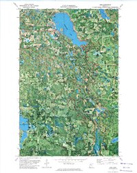
1972 Map of Debs
USGS Topo · Published 1974About this map
The Clearwater River snakes through a complex wetland and woodland landscape in this northern Minnesota orthophotomap, which combines traditional topographic contours with aerial photography. The settlement of Debs sits near the northeastern corner, serving as a focal point for the surrounding rural area. Significant water bodies such as Clearwater Lake, Myrtle Lake, and East Four Legged Lake dominate the terrain, reflecting the glaciated character of the region. The map highlights localized divisions including Sinclair, Roosevelt, Dudley, and Buzzard, which likely correspond to early townships or survey units. For family historians, the Sinclair Cem and East Zion Cem provide precise locations for ancestral research. The corridor of the Soo Line is clearly visible, marking the infrastructure that linked these lake-country settlements to broader markets. This hybrid view provides an unusually clear look at the actual land cover and vegetation patterns alongside human developments like the local Gravel Pit.
Find a feature on this map
19 named features on this map. Tap any name to fly to it.
Don’t see what you’re looking for? This feature index may not catch every label — zoom into the map to look around manually.
Map Details
Editions of this 1972 Debs Map
This is the sole edition of this map. No revisions or reprints were ever made.
Other maps of this area

1919 · Solway
USGS Topo · 1:62,500

1919 · Churnes
USGS Topo · 1:62,500

1943 · Solway
USGS Topo · 1:62,500

1943 · Bagley
USGS Topo · 1:62,500

1954 · Bemidji
USGS Topo · 1:250,000

1957 · Bemidji
USGS Topo · 1:250,000

1958 · Bemidji
USGS Topo · 1:250,000

1969 · Leonard
USGS Topo · 1:24,000

1969 · Shevlin
USGS Topo · 1:24,000

1972 · Bagley Lake
USGS Topo · 1:24,000